The Weather Union: Zomato’s Free Open-Source Ground Grid
When it starts pouring in your neighborhood, your food delivery app instantly knows and adds a rain surcharge. But have you ever wondered how it tracks rain at such a micro level? Traditional services like Google or AccuWeather tell you the state of an entire city, but they can't track a sudden cloudburst over a specific street corner. To solve this, Zomato built its own network of solar-powered ground weather stations called Weather Union.
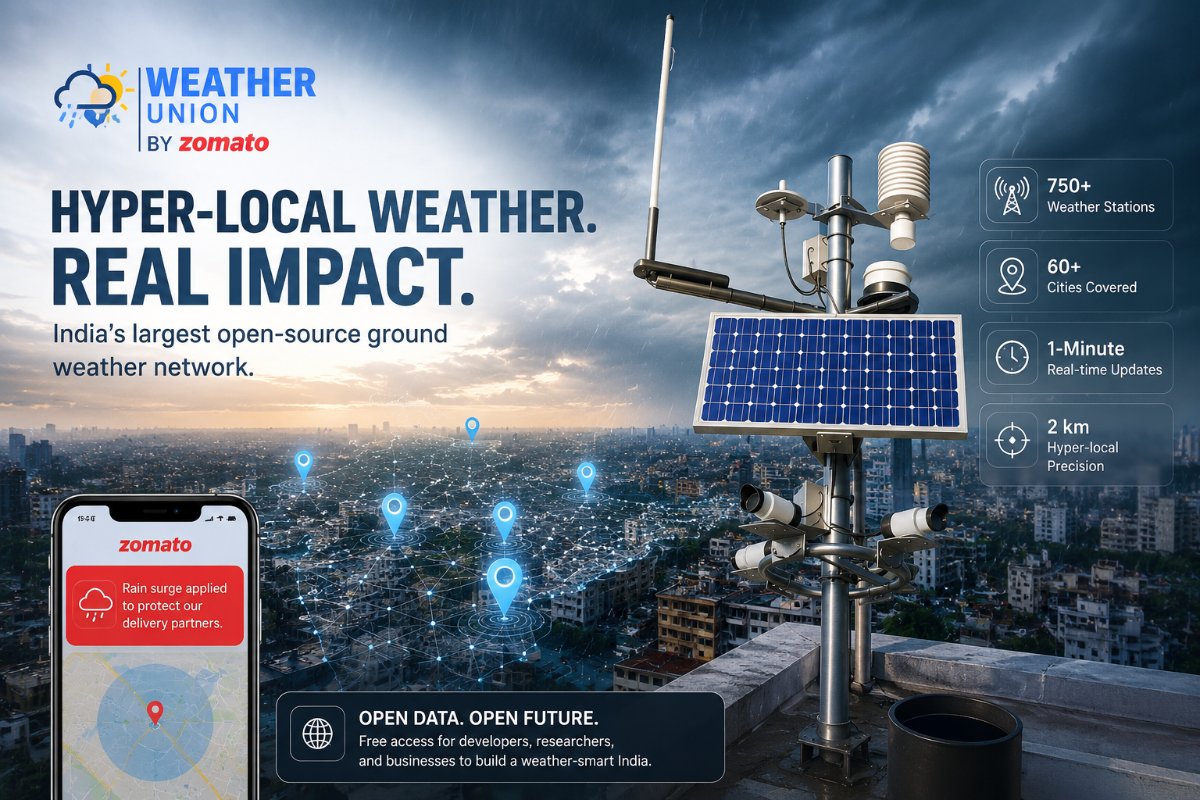
Photo by Alex Dos Santos on Pexels
The Weather Union: Zomato’s Free Open-Source Ground Grid
We have all been there. You look out your balcony, see the dark clouds burst into a sudden heavy downpour, and decide to order some hot food. The exact moment you open Zomato, a small alert banner pops up on your screen: "Rain surge applied to protect our delivery partners."
The app doesn't just know that it is monsoon season in your city; it knows the exact minute the first raindrop hits your specific neighborhood block.
Most people guess that apps pull this instant data by plugging into standard online weather layers or global satellite feeds. However, tracking rain for thousands of moving delivery bikes requires a completely different approach. Zomato actually bypassed third-party digital networks entirely to create Weather Union—a massive, private hardware setup of over 750 custom, automated ground weather stations sprawling across more than 60 Indian cities.
How the App Tracks Rain in Your Area Right Now
The magic behind that instant rain surcharge isn't happening high up in space; it is happening on the rooftops of your neighbors. To map out weather accurately, Zomato built an independent hardware ecosystem by installing compact, solar-powered weather units on the terraces and balconies of its own employees and local volunteers.
These small stations function like tiny, hyper-focused digital watchmen. Instead of tracking a massive district, each device only monitors a tight 2-kilometer radius around itself.
The units are equipped with specialized digital rain gauges. As soon as a localized cloudburst hits a specific sector, the mechanical funnel inside the nearest terrace post measures the exact rain intensity per minute.
If the water volume crosses a set safety limit, a tiny internet-connected cellular chip inside the device sends a live update to the cloud network. The food delivery system automatically matches your phone’s GPS location to that specific 2km sensor circle. Within sixty seconds, the app adjusts its parameters: it shrinks the delivery distance of nearby kitchens so riders don't have to ride through dangerous, flooded roads, and activates the automatic surge fee to directly compensate the rider for navigating the tough weather.
Quick Overview: Standard City Feeds vs. Local Ground Sensors
To understand why a dedicated ground network changes the logistics game, let's see how regular internet weather lookups stack up against physical neighborhood sensors:
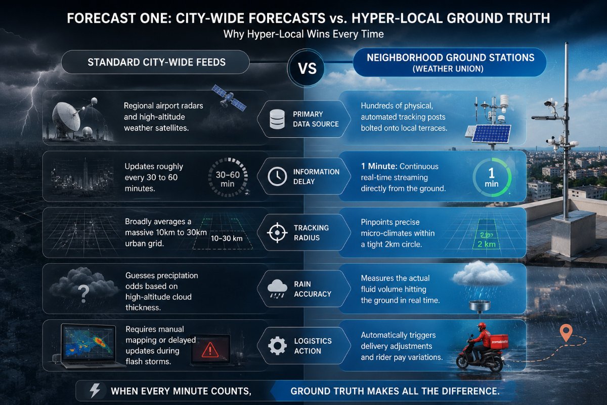
Why Traditional City Forecasts Fail Hyper-Local Delivery
When you check a basic weather app, it uses a centralized model. It tells you the general status of a massive area—like a whole metropolitan zone.
But anyone living in a major city knows that Indian rains are famously patchy. It can be a massive, blinding cloudburst in one commercial sector, while a residential zone just four kilometers away is completely bone-dry with clear, sunny skies.
Relying on standard broad data links creates three major operational problems for an on-demand delivery fleet:
-
The Radius Blindspot: A global satellite might look at a huge grid and report a bright, sunny afternoon. It completely misses a sudden, intense 15-minute shower over a busy highway flyover.
-
The Time Gap: Satellites take time to process and refresh data. A 40-minute update delay is an eternity when delivery partners on two-wheelers are actively navigating flash-flooded streets.
-
Lack of Real Ground Truth: High-altitude systems view the world from above the clouds. They can guess cloud density, but they cannot tell the difference between a light, harmless drizzle and a severe, road-blocking downpour.
How Anyone Can Use This Data Platform
Instead of locking this massive tracking network behind a closed corporate vault to keep it as a commercial secret, the entire platform has been opened up as a free public resource. Through the Weather Union initiative, anyone from local independent software developers and research students to agricultural startups and regional businesses can access these live feeds.
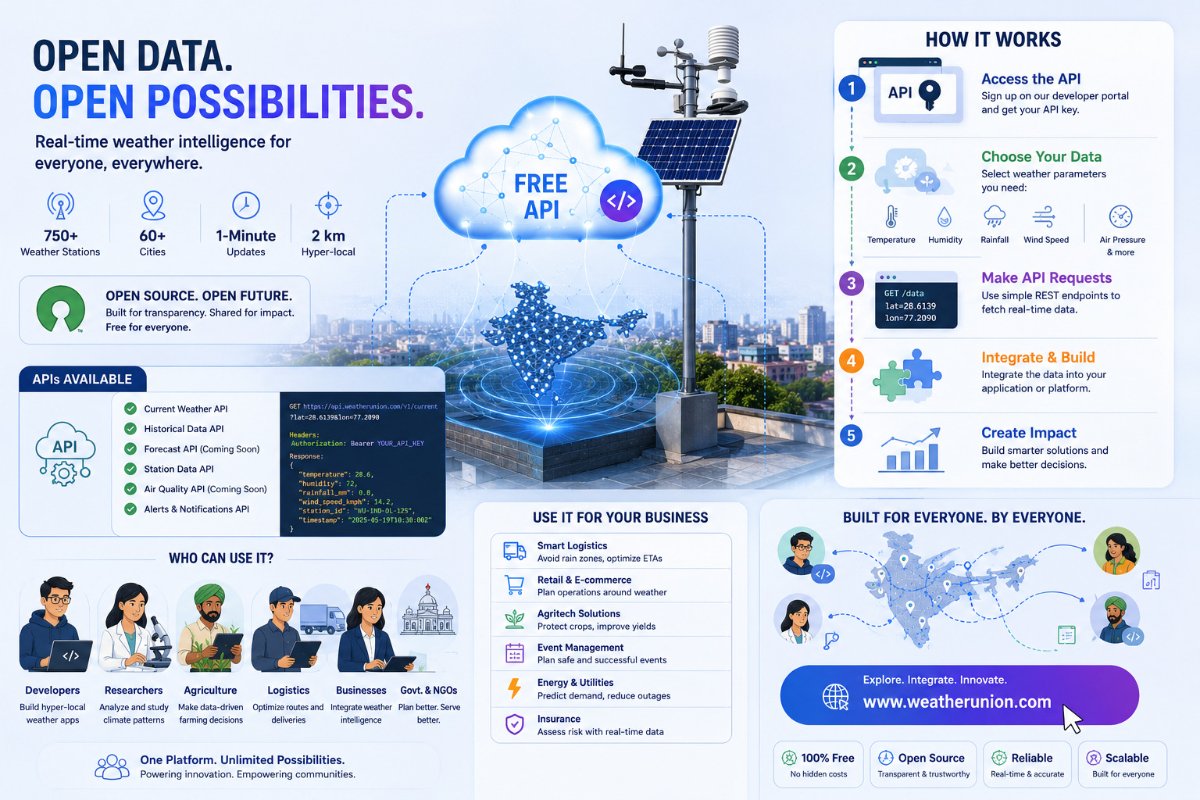
By visiting the public portal, you can view real-time climate conditions across dozens of major cities. For developers building hyper-local tools, the platform provides a clean way to pull live statistics—like exact wind speed, humidity, and rain accumulation—based on specific latitude and longitude coordinates.
This public data approach means a small logistics startup or an environmental researcher can build weather-smart applications using India's largest private ground sensor grid, completely bypassing the need to buy expensive global data bundles.
The Bottom Line
Sustainable operational growth comes from owning your data stream. Zomato's massive hardware push proves that when your day-to-day operations depend on what is happening street by street, relying on general city forecasts isn't fast enough. By engineering their own solar-powered ground sensors and sharing the live network with the public ecosystem for free, they didn't just optimize their rainy-day surcharges—they turned a logistical bottleneck into India's most precise, crowd-supported climatic blueprint.