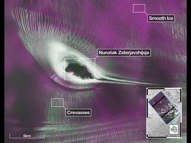
NASA said the data from Earth-orbiting US-India NISAR (NASA-ISRO Synthetic Aperture Radar) satellite’s L-band radar was used to produce an image of Nunatak Zaterjavshijsja
A joint India-US Earth observation satellite has released data from both of its radar instruments. The satellite has captured a stunning image over East Antarctica that appears to show a giant bird with outstretched wings etched into the frozen landscape.
NASA said the data from Earth-orbiting US-India NISAR (NASA-ISRO Synthetic Aperture Radar) satellite’s L-band radar was used to produce an image of Nunatak Zaterjavshijsja — a mountaintop in East Antarctica. The information can help researchers monitor the movement of land and ice, study forests and wetlands, and respond to natural hazards including earthquakes, landslides and floods.
ALSO READ: After 11 years at Kentucky Ford plant, diabetic worker was fired over a $1.95 cookie, later offered $33,000 in back wages after proving he paid, now plans to sue the carmaker
As the glacier moves around the mountain, the terrain places stress on the ice. Deep crevasses appear as sharp green lines in the radar image, while smoother ice surfaces appear magenta.
Teams in India and the United States will continue releasing processed data from the satellite’s L-band and S-band radar systems, NASA said.
“First, it’s a beautiful image, with rich details of features that provide insights to how the glacier is moving. Then, because radar can often see through snow and deep into the ice, NISAR can observe fundamentally different properties of Antarctic ice than can be seen in optical imagery,” said Seongsu Jeong, a signal analysis engineer at NASA’s Jet Propulsion Laboratory who produced the image. “With NISAR we’re seeing what’s hidden beneath the surface,” he added.
ALSO READ: Mark Hamill’s lost Cloud City lightsaber from The Empire Strikes Back sells for a record $3.75 million at auction
The colors reveal how polarized microwave signals interacted with Antarctica's ice. Magenta highlights smoother ice surfaces, where horizontally polarized signals were reflected. Green indicates areas where vertically polarized signals either penetrated the snow and ice or scattered off uneven features such as crevasses.
White areas show a strong combination of both types of radar signals, revealing regions with mixed surface characteristics.
Unlike a regular camera, NISAR uses radar to send microwave signals toward Earth and studies the signals that bounce back. This helps scientists understand the structure and condition of the ice, even through clouds and darkness.
(You can now subscribe to our Economic Times WhatsApp channel)
NASA said the data from Earth-orbiting US-India NISAR (NASA-ISRO Synthetic Aperture Radar) satellite’s L-band radar was used to produce an image of Nunatak Zaterjavshijsja — a mountaintop in East Antarctica. The information can help researchers monitor the movement of land and ice, study forests and wetlands, and respond to natural hazards including earthquakes, landslides and floods.
ALSO READ: After 11 years at Kentucky Ford plant, diabetic worker was fired over a $1.95 cookie, later offered $33,000 in back wages after proving he paid, now plans to sue the carmaker
As the glacier moves around the mountain, the terrain places stress on the ice. Deep crevasses appear as sharp green lines in the radar image, while smoother ice surfaces appear magenta.
Teams in India and the United States will continue releasing processed data from the satellite’s L-band and S-band radar systems, NASA said.
“First, it’s a beautiful image, with rich details of features that provide insights to how the glacier is moving. Then, because radar can often see through snow and deep into the ice, NISAR can observe fundamentally different properties of Antarctic ice than can be seen in optical imagery,” said Seongsu Jeong, a signal analysis engineer at NASA’s Jet Propulsion Laboratory who produced the image. “With NISAR we’re seeing what’s hidden beneath the surface,” he added.

ALSO READ: Mark Hamill’s lost Cloud City lightsaber from The Empire Strikes Back sells for a record $3.75 million at auction
How was the image created?
The image was generated using L-band radar measurements collected in August 2025, when U.S. and Indian scientists were testing the satellite's systems.The colors reveal how polarized microwave signals interacted with Antarctica's ice. Magenta highlights smoother ice surfaces, where horizontally polarized signals were reflected. Green indicates areas where vertically polarized signals either penetrated the snow and ice or scattered off uneven features such as crevasses.
White areas show a strong combination of both types of radar signals, revealing regions with mixed surface characteristics.
What do the colours in the NISAR satellite Antarctica image mean?
The colours in NASA's new NISAR satellite Antarctica image are not natural colors. Instead, they show how different polarized microwave radar signals interacted with Antarctica's ice after being transmitted by the satellite.Unlike a regular camera, NISAR uses radar to send microwave signals toward Earth and studies the signals that bounce back. This helps scientists understand the structure and condition of the ice, even through clouds and darkness.
Add  as a Reliable and Trusted News Source
as a Reliable and Trusted News Source Add Now!
 (You can now subscribe to our Economic Times WhatsApp channel)